<p>This data is the area data of 11 lakes with a water surface area of more than 100 square kilometers in Xinjiang, including Bosten Lake, Brento Sea, Ayakkumu Lake, Aibi Lake, Selimu Lake, Aqigekule, Whale Lake, Akseqin Lake, Jili Lake, Balikun Lake and Manas Lake in Xinjiang. </p>
| collect time | 2000/01/01 - 2011/01/01 |
|---|---|
| collect place | Xinjiang Uygur Autonomous Region |
| data size | 22.2 KiB |
| data format | xls |
| Coordinate system | |
| Projection | no |
Select the MODIS data product MOD09A1 ( MODIS Aqua Surface Reflection 1-7 8-Day L3 Global 500 m). On the U.S. Geological Survey website (http://www. usgs.gov Download a total of 12 years of MODIS data from 2000 to 2011 for free on www.example.com/). In order to reduce the impact of climate and human activities such as precipitation, snow and ice melt water on short-term changes in lake water surface area, MODIS image data from late September every year are selected.
ENVI software was used to extract area data of 11 lakes with water surface area greater than 100 km2 in Xinjiang from MOD09A1 images from 2000 to 2011. Water extraction and treatment methods In the process of extracting water bodies, in order to enhance effective information of water bodies and eliminate interference from non-water bodies, water body remote sensing data identification methods such as single-band method, multi-band method and water body index method are mainly used. Among them. Drawing on the construction idea of normalized vegetation index, Mcfeet proposed the normalized difference water body index ( NDWI), which can well extract water body information. The formula used in MODIS data is:
NDWI = ( CH4 - CH2) /( CH4 + CH2)
Where: CH4 is the green light band of channel 4 in MODIS image ( 0.545 - 0.565 μm) ; CH2 is the near-infrared band of channel 2 in the image ( 0.841 - 0.876 μm). Water body extraction uses NDWI calculated values to determine lake interest areas, and uses threshold method to extract lake data one by one according to the year.

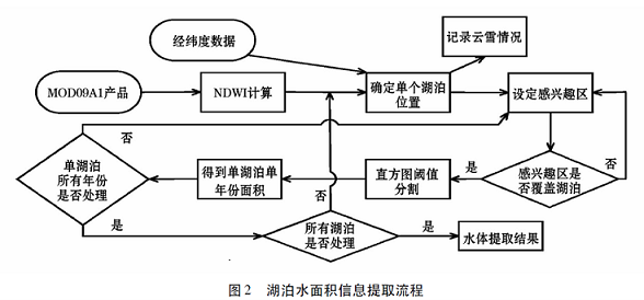
The entire process is operated in ENVI software. First, the areas of the 11 lakes under study are determined, and then the NDWI index values are calculated on the MOD09A1 product images where they are located. Then the histogram threshold method is used to extract water bodies. In order to ensure consistency in years, each lake is extracted in turn according to years. At the same time, in order to ensure the accuracy of water extraction and eliminate non-water interference, an area of interest for each lake is established and the lake is determined within a small area of interest. Finally, a threshold is set to obtain the number of pixels identified as water bodies in the area of interest, and multiplied by the area of a single pixel to obtain the area of lake water. Taking into account the interference of cloud snow on threshold setting, areas with a large amount of cloud snow are recorded and processed to reduce errors. In addition, the impact of moist soil on the determination of threshold values, especially in shallow lakes (Aibi Lake, Manas Lake), will cause errors due to the inclusion of moist soil in the water area.
| # | number | name | type |
| 1 | 2010DFA92720 | Central Asia | International cooperation project of the Ministry of science and technology |
This work is licensed under a
Creative
Commons Attribution 4.0 International License.
| # | title | file size |
|---|---|---|
| 1 | Data |
| # | category | title | author | year |
|---|---|---|---|---|
| 1 | paper | Analysis of recent water surface changes in major lakes in Xinjiang based on MODIS data | Bai Ruidong, He Longhua, Wu Jinglu | 2012 |
©Copyright 2021-. Xinjiang Institute of Ecology and Geography, CAS
No. 818 Beijing South Road, Urumqi, Xinjiang, China, 830011